|
TERMS OF USE:
This free image can only be used for non-commercial, personal
website use only. THIS IMAGE CANNOT BE
used in galleries, downloaded to your computer, posted on sites for
others to use, manipulated, downsized, or upsized. If you are confused about the
terms of use or have any questions then contact us before using the image.
Free Picture: Hurricane Jeanne
|
Description
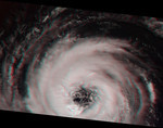
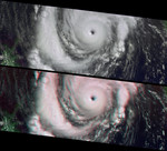
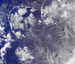
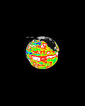
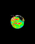
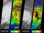
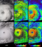
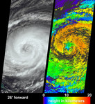
After causing widespread destruction on Puerto Rico, Haiti and the Dominican Republic, Hurricane Jeanne was weakened to Tropical Storm status for several days before it regained strength over the Bahamas as a Category 2 hurricane. When Jeanne made landfall in U.S. territory on September 26 it was the fourth major hurricane of the 2004 Atlantic hurricane season to strike Florida. These visualizations of Hurricane Jeanne on September 24 were captured by NASA's Multi-angle Imaging SpectroRadiometer (MISR). The still panels include a natural color view from MISR's 26-degree forward-viewing camera (left) and a two dimensional map of cloud-top heights (right). In addition, a "multi-angle fly-over" is provided as an animation using views from all nine MISR cameras. The nine camera views which make up the animation have been processed to give an approximate perspective view. The animation makes visible the relative heights of clouds within the scene. Some of the real cloud motion over the seven minutes during which all nine MISR cameras observed the scene are also indicated by the animation. The cloud height map was produced by automated computer recognition of the distinctive spatial features between images acquired at different view angles. Two-dimensional maps of cloud height such as these offer an opportunity to compare simulated cloud fields against actual hurricane observations. Results indicate that clouds within Jeanne had attained altitudes of more than 16 kilometers above sea level. The height field pictured here is uncorrected for the effects of cloud motion. Wind-corrected heights have higher accuracy but sparser spatial coverage.
Keywords
earth science, hurricane, hurricanes, jpl, nasa, storm, storms, tropical storm, tropical storms, weather, hurricane jeanne, free photography, free photo, free photos, free picture, free pictures, free image, free images
|
Similar Free weather Pictures
|
|
|
|