|
TERMS OF USE:
This free image can only be used for non-commercial, personal
website use only. THIS IMAGE CANNOT BE
used in galleries, downloaded to your computer, posted on sites for
others to use, manipulated, downsized, or upsized. If you are confused about the
terms of use or have any questions then contact us before using the image.
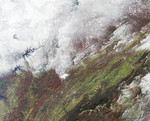
Free Picture: Snowfall in Southern Appalachia
|
Description
The snowstorm which swept across the eastern United States on December 4 and 5 also brought the season's first snow to parts of the south and southern Appalachia. The extent of snow cover over central Kentucky, eastern Tennessee, western North Carolina and Virginia are apparent in this view from the Multi-angle Imaging SpectroRadiometer (MISR). This natural-color image was captured by MISR's downward-looking (nadir) camera on December 7, 2002. The Appalachians are bounded by the Blue Ridge mountain belt along the east and the Appalachian Plateau along the west. Valleys and ridges between the higher elevation areas retain the green and reddish-brown hues of autumn, and many rivers and lakes appear blue and unfrozen. The highest peak in the eastern United States, Mount Mitchell, is found in North Carolina's western tip, near the Great Smoky Mountains (the dark-colored range at lower right).
Keywords
appalachia, appalachian plateau, appalachians, blue ridge mountain, blue ridge mountain belt, blue ridge mountains, geography, great smoky mountains, jpl, kentucky, mount mitchell, nasa, north carolina, snow, snowfall, snowstorm, southern appalachia, tennessee, virginia, weather, snowfall in southern appalachia, free photography, free photo, free photos, free picture, free pictures, free image, free images
|
Similar Free geography Pictures
|
|
|
|


