|
TERMS OF USE:
This free image can only be used for non-commercial, personal
website use only. THIS IMAGE CANNOT BE
used in galleries, downloaded to your computer, posted on sites for
others to use, manipulated, downsized, or upsized. If you are confused about the
terms of use or have any questions then contact us before using the image.
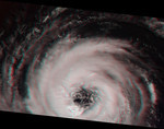
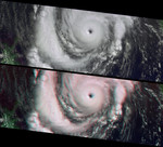
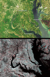
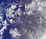
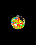
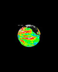
Free Picture: Aspects of Hurricane Isabel

|
Description
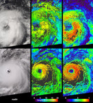
Cloud-top radiance and height characteristics of Hurricane Isabel are depicted in these data products and animations from the Multi-angle Imaging SpectroRadiometer (MISR). Isabel was upgraded to hurricane status a few hours after the top image panels in this set were acquired on September 7, 2003. By the time the bottom panels were acquired on September 11,Isabel was a strengthening category 4 hurricane, centered about 900 kilometers east-northeast of the Leeward Islands. Along the left are radiance images from MISR's vertical-viewing (nadir)camera, at center are cloud-top height fields, and the right-hand panels provide retrieved local albedo values. The cloud-top heights are retrieved using automated stereoscopic processing of data from multiple MISR cameras, and are uncorrected at this stage for the effects of the exceptionally high winds associated with the hurricane's rotation. Albedo values are dependent upon the observed cloud radiances as a function of view angle and upon the cloud height field, and are well-represented here. Albedo is a function of the amount of sunlight reflected back to space divided by the amount of incident sunlight. Cloud height and albedo are among the principle variables governing the influences of clouds on climate. Areas where height and albedo could not be retrieved are shown in dark grey.
Keywords
earth science, hurricane isabel, isabel, jpl, nasa, storm, storms, weather, aspects of hurricane isabel, free photography, free photo, free photos, free picture, free pictures, free image, free images
|
Similar Free weather Pictures
|
|
|
|