|
TERMS OF USE:
This free image can only be used for non-commercial, personal
website use only. THIS IMAGE CANNOT BE
used in galleries, downloaded to your computer, posted on sites for
others to use, manipulated, downsized, or upsized. If you are confused about the
terms of use or have any questions then contact us before using the image.
Free Picture: Roiling Clouds of Katrina
|
Description
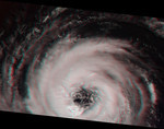
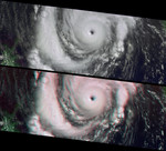
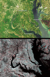
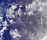
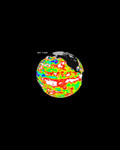
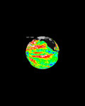
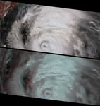
This image pair from NASA's Multi-angle Imaging SpectroRadiometer (MISR) shows the strong convective development of Hurricane Katrina on Saturday, August 27 as it moved west through the Gulf of Mexico. At this time, Katrina was undergoing rapid development -- it had just been upgraded to a Category 3 hurricane, and within 24 hours it would reach Category 5. On Monday morning when the eyewall made landfall over the United States, it was again a Category 4 storm. Hurricane Katrina is one of the most powerful and destructive storms on record for the Atlantic Basin. The vertical and horizontal development of the convective clouds and the formation of an outer ring of growing clouds (referred to as an "eyewall replacement cycle") also indicates rapid strengthening. During this stage of hurricane development, an outer band of clouds may gradually move inward to replace the existing hurricane eyewall, causing the central pressure to increase and weaken the storm in the short term, but eyewall replacement may sometimes be a forerunner for rapid strengthening in the longer term. This was the case with Hurricane Katrina, whose central pressure increased slightly on Saturday, but then dropped again significantly on Sunday when Katrina became a Category 5 storm. Observing the development of a concentric eyewall at this spatial and temporal resolution is a unique feature of these MISR observations. The top panel of the still images is a false-color view (near-infrared, red, and blue displayed as red, green and blue) from MISR's nadir (vertically downward pointing) camera. The vegetated Alabama coast in the upper left-hand corner appears here in red hues. The bottom panel is a 3-D stereo anaglyph created with red band data from MISR's 70-degree forward-viewing and 60-degree forward-viewing cameras, displayed as red and green/blue, respectively. For the still images, north is at the left. To observe the height variations in 3-D, you will need to use red/blue glasses.
Keywords
earth science, hurricane, hurricane katrina, hurricanes, jpl, katrina, nasa, science, storm, storms, tropical storm, tropical storm katrina, tropical storms, weather, roiling clouds of katrina, free photography, free photo, free photos, free picture, free pictures, free image, free images
|
Similar Free weather Pictures
|
|
|
|