|
TERMS OF USE:
This free image can only be used for non-commercial, personal
website use only. THIS IMAGE CANNOT BE
used in galleries, downloaded to your computer, posted on sites for
others to use, manipulated, downsized, or upsized. If you are confused about the
terms of use or have any questions then contact us before using the image.
Free Picture: Tracking Hurricane Wilma Across the Caribbean
|
Description
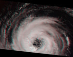
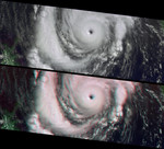
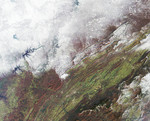
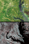
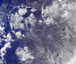
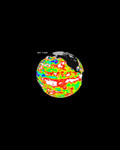
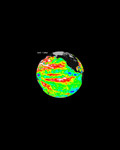
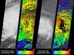
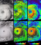
Image showing the tracking of Hurricane Wilma across the Caribbean. Information on cloud top heights at different stages in the life cycle of the rapidly intensifying Hurricane Wilma may prove useful for evaluating the ability of numerical weather models to predict the intensity changes of hurricanes. NASA's Multi-angle Imaging SpectroRadiometer (MISR) acquired this sequence of images and cloud-top height observations for Hurricane Wilma as it progressed across the Caribbean in October 2005. Each pair in the sequence has a photo-like view of the storm on the left and a matching color-coded image of cloud-top height on the right. Cloud-top heights range from 0 (purple) to 18 (red) kilometers altitude. Areas where cloud heights could not be determined are shown in dark gray. The pair on the left show Wilma on Tuesday, October 18, when Hurricane watches were posted for Cuba and Mexico. The central pair shows the eye of Hurricane Wilma just hours before the storm began to cross the Yucatan Peninsula on Friday, October 21. At that time, Wilma was a powerful Category 4 Hurricane on the Saffir-Simpson scale, and had a minimum recorded central pressure of 930 millibars. Hurricane Wilma surged from tropical storm to Category 5 hurricane status in record time, but the storm slowed and weakened considerably after battering Mexico's Yucatan Peninsula and the Caribbean. The right-hand image pair displays the eastern edges of a weakened Wilma, when Wilma had been reduced to Category 2 status and was just starting to reach southern Florida on the morning of Sunday, October 23. Wilma gathered speed and strengthened on Sunday night, crossing Florida as a Category 3 storm on Monday, October 24. On the 18th, Wilma looked a bit ragged. Its eye is located at the center of the left edge, and its outer bands of clouds appear to be dominated by a rather loose collection of thunderstorms. In the photo-like images, these look like areas of "boiling clouds," and in the cloud-height image, the
Keywords
caribbean, category 5 hurricane, earth science, hurricane, hurricanes, jpl, nasa, storm, storms, weather, wilma, hurricane wilma, free photography, free photo, free photos, free picture, free pictures, free image, free images
|
Similar Free weather Pictures
|
|
|
|