
|
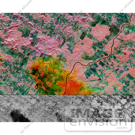
This multi-frequency space radar image of a tropical rainforest in western Brazil shows rapidly changing land use patterns and it also demonstrates the capability of the different radar frequencies to detect and penetrate heavy rainstorms. This color image was created by combining the three separate radar frequencies into a composite image. The three black and white images below represent the individual frequencies. The lower left image, X-band vertically transmitted and received, is blue in the color image; the lower center image, C-band horizontally transmitted and vertically received is green; and the lower right image, L-band horizontally transmitted and vertically received is red. A heavy downpour in the lower center of the image appears as a black "cloud" in the X-band image, the same area is shows up faintly in the C-band image, and is invisible in the L-band image. When combined in the color image, the rain cell appears red and yellow. Although radar can usually "see" through clouds, short radar wavelengths (high frequency), such as X and C-band, can be changed by unusually heavy rain cells. L-band, at a 24 cm (9 inches) wavelength, is unaffected by such rain cells. By analyzing the way the radar changes, scientist can estimate rainfall rates. The area shown is in the state of Rondonia, in western Brazil. The pink areas are pristine tropical rainforest, and the blue and green patches are areas where the forest has been cleared for agriculture. Cleared areas are typically able to support intense farming for a only few years, before soil erosion renders the fields unusable. Radar imaging can be used to monitor not only the rainforest destruction, but also the rates of recovery of abandoned fields. This image is 35.2 kilometers by 21.3 kilometers (21.8 miles by 13.2 miles) and is centered at 11.2 degrees south latitude, 61.7 degrees west longitude. North is toward the upper left. Photo Credit: NASA/JPL [0003-0701-1019-1718] by 0003
|
Keywords
brazil, geography, jpl, nasa, radar image, radar images, rainforest, rainforests, randonia rain cell
|
|

