Stock Photography of a Map of the Contiguous United States of America and the Great Lakes #26949


#26949 Stock Photography of a Map of the Contiguous United States of America and the Great Lakes by JVPD
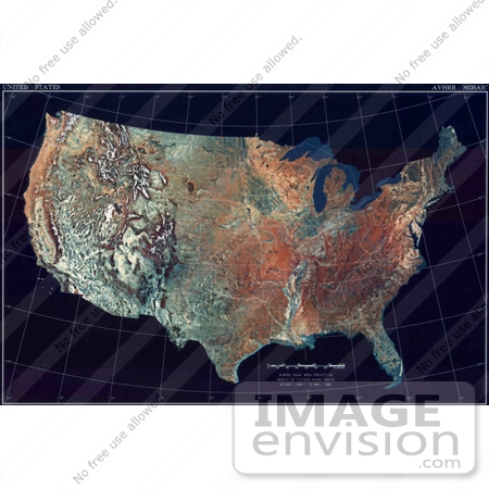
Royalty-free geography stock photo of a map of the contiguous United States of America and the Great Lakes.

Photo Credit: U.S. Dept. of Commerce/National Climactic Data Center/NOAA Satellite and Information Service [0003-0804-1721-0326] by 0003

Similar Images:

#3253 Lost Hills by JVPD
#10590 Picture of a Soldier Using a Map and Compass by JVPD
#7324 Picture of a 1967 Map that Shows Several Relief Camps Surrounding The Nigerian-Biafran War Zone by KAPD
#2681 Eurasia by JVPD
#2684 Picture of Continents of the Earth by JVPD
#6440 Picture of a Map Showing an Area to be Sprayed with Malathion During the 1976 Pakistani Anti-Mosquito Campaign by KAPD
#53886 Royalty-Free Stock Photo of a GPS Computer  by Maria Bell
#8925 Picture of a Soldier Checking Map Coordinates by JVPD
#3304 Global City Lights by JVPD
#1434 Global Sea Surface Temperature 7/1984 by JVPD
#6434 Picture of a Map Showing Areas Sprayed During the 1976 Pakistani Malathion Campaign by KAPD
#2667 Global Average Brightness Temperature for April 2003 by JVPD
#1433 First Photo of U.S. by NASA Satellite 4/26/1974 by JVPD
#2901 Light of Day by JVPD
More Map Photos

Keywords

contiguous united states, contiguous united states of america, contiguous us, contiguous usa, countries, country, education, educational, geography, great lakes, map, maps, noaa, the great lakes, topographical map, topographical maps, topography, united states, united states of america, us, usa