
|
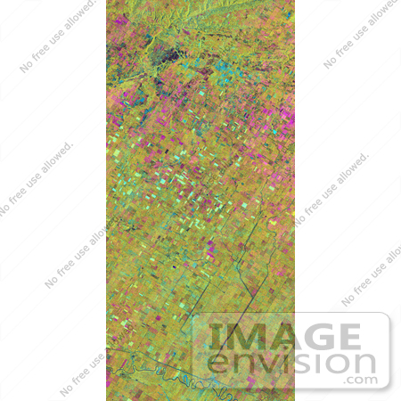
NASA image of the Altona test site in Manitoba, Canada. The test site is located in the Red River Basin and is characterized by rich farmland where a variety of crops are grown, including wheat, barley, canola, corn, sunflowers and sugar beets. This SIR-C/X-SAR research site is applying radar remote sensing to study the characteristics of vegetation and soil moisture. The seasonal comparison between the April and October 1994 data show the dramatic differences between surface conditions on the two dates. At the time of the April acquisition, almost all agricultural fields were bare and soil moisture levels were high. In October, however, soils were drier and while most crops had been harvested, some standing vegetation was still present. The areas which are cyan in color are dark in April and bright in October. These represent fields of standing biomass (amount of vegetation in a specified area) and the differences in brightness within these cyan fields represent differences in vegetation type. The very bright fields in October represent standing broadleaf crops such as corn, which had not yet been harvested. Other standing vegetation which has less biomass, such as hay and grain fields, are less bright. The magenta indicates bare soil surfaces which were wetter (brighter) in April than in October. The variations in brightness of the magenta indicate differences in the degree of soil moisture change and differences in surface roughness. This seasonal composite demonstrates the sensitivity of radar to changes in agricultural surface conditions such as soil moisture, tillage, cropping and harvesting. Photo Credit: NASA/JPL [0003-0701-1019-1348] by 0003
|
Keywords
altona, canada, geography, jpl, manitoba, nasa, red river basin
|
|


