
|
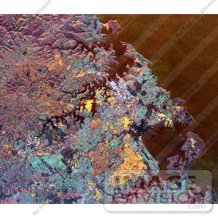
NASA radar image of Sydney, Australia. Sydney Harbour, with numerous coves and inlets, is seen in the upper center of the image, and the roughly circular Botany Bay is shown in the lower right. The downtown business district of Sydney appears as a bright white area just above the center of the image. The Sydney Harbour Bridge is a white line adjacent to the downtown district. The well-known Sydney Opera House is the small, white dot to the right of the bridge. Urban areas appear yellow, blue and brown. The purple areas are undeveloped areas and park lands. Manly, the famous surfing beach, is shown in yellow at the top center of the image. Runways from the Sydney Airport are the dark features that extend into Botany Bay in the lower right. Botany Bay is the site where Captain James Cook first landed his ship, Endeavour, in 1770. The image was acquired by the Spaceborne Imaging Radar-C/X-band Synthetic Aperture Radar (SIR-C/X-SAR) on April 20, 1994, onboard the space shuttle Endeavour. The area shown is 33 kilometers by 38kilometers (20 miles by 23 miles) and is centered at 33.9 degrees south latitude, 151.2 degrees east longitude. North is toward the upper left. The colors are assigned to different radar frequenciesand polarizations as follows: red is L-band, vertically transmittedand horizontally received; green is C-band, vertically transmitted and horizontally received; and blue is C-band, vertically transmittedand received. SIR-C/X-SAR, a joint mission of the German, Italianand United States space agencies, is part of NASA's Mission to Planet Earth. Photo Credit: NASA/JPL [0003-0701-1018-5103] by 0003
|
Keywords
australia, botany bay, from space, geography, jpl, nasa, sydney, sydney airport, sydney australia, sydney australia from space, sydney from space, sydney harbour, sydney harbour bridge, sydney opera house, view from space
|
|


