
|
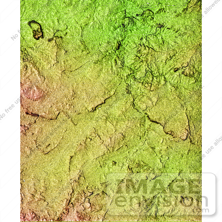
Located north of the Swartberg Mountains in South Africa's Northern Cape Province, this topographic image shows a portion of the Great Karoo region. Karoo is an indigenous word for "dry thirst land." The semi-arid area is known for its unique variety of flora and fauna. The topography of the area, with a total relief of 200 meters (650 feet), reveals much about the geologic history of the area. The linear features seen in the image are near-vertical walls of once-molten rock, or dikes, that have intruded the bedrock. The dikes are more resistant to weathering and, therefore, form the linear wall-like features seen in the image. In relatively flat arid areas such as this, small changes in the topography can have large impacts on the water resources and the local ecosystem. These data can be used by biologists to study the distribution and range of the different plants and animals. Photo Credit: NASA/JPL-Caltech [0003-0701-0820-0710] by 0003
|
Keywords
africa, geography, great karoo, jpl, karoo, nasa, northern cape province, south africa
|
|


