
|
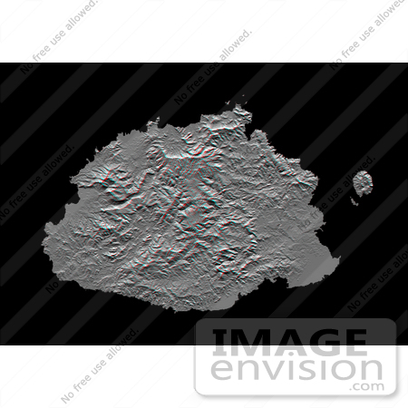
The Sovereign Democratic Republic of the Fiji Islands, commonly known as Fiji, is an independent nation consisting of some 332 islands surrounding the Koro Sea in the South Pacific Ocean. This topographic image shows Viti Levu, the largest island in the group. With an area of 10,429 square kilometers (about 4000 square miles), it comprises more than half the area of the Fiji Islands. Suva, the capital city, lies on the southeast shore. The Nakauvadra, the rugged mountain range running from north to south, has several peaks rising above 900 meters (about 3000 feet). Mount Tomanivi, in the upper center, is the highest peak at 1324 meters (4341 feet). The distinct circular feature on the north shore is the Tavua Caldera, the remnant of a large shield volcano that was active about 4 million years ago. Gold has been mined on the margin of the caldera since the 1930s. The Nadrau plateau is the low relief highland in the center of the mountain range. The coastal plains in the west, northwest and southeast account for only 15 percent of Viti Levu's area but are the main centers of agriculture and settlement. This shaded relief anaglyph image was generated using preliminary topographic data from the Shuttle Radar Topography Mission. A computer-generated artificial light source illuminates the elevation data from the top (north) to produce a pattern of light and shadows. Slopes facing the light appear bright, while those facing away are shaded. The stereoscopic effect was created by first draping the shaded relief image back over the topographic data and then generating two differing perspectives, one for each eye. When viewed through special glasses, the result is a vertically exaggerated view of the Earth's surface in its full three dimensions. Anaglyph glasses cover the left eye with a red filter and cover the right eye with a blue filter. Photo Credit: NASA/JPL/NIMA [0003-0701-0722-5757] by 0003
|
Keywords
3d, anaglyph, anaglyphs, fiji, fiji islands, geography, island, islands, jpl, koro sea, mount tomanivi, nadrau plateau, nakauvadra, nasa, sovereign democratic republic of the fiji islands, suva, tavua caldera, viti levu
|
|


