Mt. Pinos and San Joaquin Valley #3332


#3332 Mt. Pinos and San Joaquin Valley by JVPD
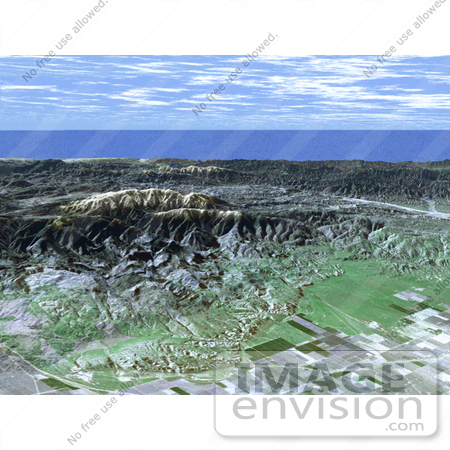
Ask any astronomer where the best stargazing site in Southern California is, and chances are they'll say Mt. Pinos. In this perspective view generated from SRTM elevation data the snow-capped peak is seen rising to an elevation of 2,692 meters (8,831 feet), in stark contrast to the flat agricultural fields of the San Joaquin valley seen in the foreground. Below the summit, but still well away from city lights, the Mt. Pinos parking lot at 2,468 meters (8,100 feet) is a popular viewing area for both amateur and professional astronomers and astro-photographers. For visualization purposes, topographic heights displayed in this image are exaggerated two times. You can see crops in the foreground.

Photo Credit: NASA/JPL/NIMA [0003-0701-0722-5159] by 0003

Similar Images:

#3573 Great Wall of China From Space by JVPD
#19245 Photo of the Artificial Palm Island, Palm Jumeirah, on the Persian Gulf in Dubai by JVPD
#3253 Lost Hills by JVPD
#25455 Stock Photo of a Vetical Cropped Image of the State of Florida as Seen From Space by JVPD
#2898 Pulau Kimaam, West Papua by JVPD
#26949 Stock Photography of a Map of the Contiguous United States of America and the Great Lakes by JVPD
#35500 Geography Stock Photo Of The Strait Of Magellan, Chile As Seen From Space by JVPD
#2882 Bosporus Strait and Istanbul, Turkey by JVPD
#2685 Picture of World Globes - Three Views of Earth by JVPD
#3343 Cape Cod From Space by JVPD
#3298 Mexicali, Calexico by JVPD
#3619 Cape Cod From Space by JVPD
#3323 Liquefaction Effects, Bhuj Earthquake by JVPD
#3239 Republic of Fiji by JVPD
#3626 Boston From Space by JVPD
More Geography Photos

Keywords

agricultural, agriculture, ca, calif, california, crops, geography, jpl, mount pinos, mt pinos, nasa, san joaquin, san joaquin valley