Lofoten Islands, Norway #3271


#3271 Lofoten Islands, Norway by JVPD
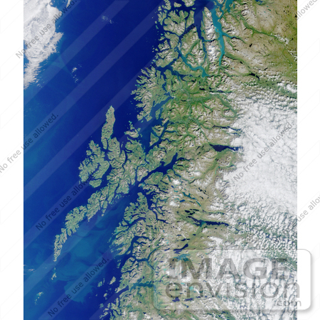
Nasa image of the Lofoten Islands. This glaciated coastline of Norway is deeply indented by fjords, rises precipitously to high plateaus, and is united with the ocean by numerous islands. This MISR image from Terra orbit 8899 displays some of intricate patterns of the ocean currents in the Vestfjorden between the mainland and Lofoten islands, in addition to many fjords, lakes and mountains.

Photo Credit: NASA/GSFC/LaRC/JPL, MISR Team [0003-0701-0712-0812] by 0003

Similar Images:

#3573 Great Wall of China From Space by JVPD
#19245 Photo of the Artificial Palm Island, Palm Jumeirah, on the Persian Gulf in Dubai by JVPD
#3253 Lost Hills by JVPD
#25455 Stock Photo of a Vetical Cropped Image of the State of Florida as Seen From Space by JVPD
#2898 Pulau Kimaam, West Papua by JVPD
#26949 Stock Photography of a Map of the Contiguous United States of America and the Great Lakes by JVPD
#35500 Geography Stock Photo Of The Strait Of Magellan, Chile As Seen From Space by JVPD
#2882 Bosporus Strait and Istanbul, Turkey by JVPD
#2685 Picture of World Globes - Three Views of Earth by JVPD
#3343 Cape Cod From Space by JVPD
#3619 Cape Cod From Space by JVPD
#3298 Mexicali, Calexico by JVPD
#3323 Liquefaction Effects, Bhuj Earthquake by JVPD
#3239 Republic of Fiji by JVPD
#3626 Boston From Space by JVPD
More Geography Photos

Keywords

coastline, fjords, geography, island, islands, jpl, lofoten islands, lofoten islands norway, nasa, norway