
|
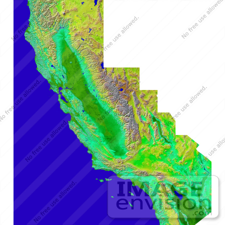
The diversity of landforms that make up the state of California is evident in this new rendition of the 3-D topography of the state. The Central Valley, flanked on the east by the Sierra Nevada, dominates the scene with San Francisco and Monterey Bays clearly visible at left center. Other features of interest include Lake Tahoe at the edge to the right of San Francisco, Mono Lake below Lake Tahoe, and the Salton Sea at the lower right. The prominent sideways "V" in the southern part of the state is the intersection of the Garlock and San Andreas Faults - to the east is the Mojave Desert. Offshore are the Channel Islands and to the right of them lies the city of Los Angeles. Two visualization methods were combined to produce this image: shading and color coding of topographic height. The shade image was derived by computing topographic slope in the northwest-southeast direction. North-facing slopes appear bright and south-facing slopes appear dark. Color coding is directly related to topographic height, with blue and green at the lower elevations, rising through yellow and brown to white at the highest elevations. Photo Credit: NASA/JPL/NIMA [0003-0701-0214-1037] by 0003
|
Keywords
3d, ca, cali, calif, california, california mosaic, central valley, channel islands, fault, faults, garlock fault, geography, jpl, lake tahoe, los angeles, mojave desert, mono lake, monterey bay, nasa, salton sea, san andreas fault, san francisco bay, sierra nevada, state
|
|


