
|
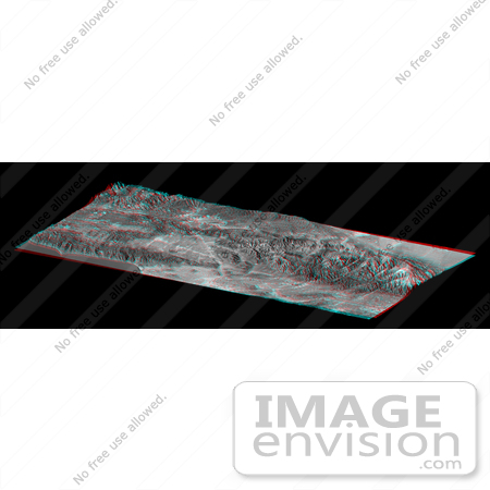
The Shuttle Radar Topography Mission (SRTM) has produced the first high-resolution, near-global elevation dataset of Earth. In recognition of this achievement, and as an illustration of the data, the United States Library of Congress now displays a "solid terrain model" of Los Angeles and adjacent mountainous terrain. The model was created by carving a high-density foam block using computer-guided drills that referenced the SRTM dataset. The block was then covered with a Landsat satellite image using computer-guided paint guns that referenced both the Landsat image and the SRTM dataset. The view shown here mimics the actual model on display at the Library of Congress and was generated from the same satellite image and elevation data sets. Anaglyph glasses are required to see this view in three-dimensions. Anaglyph glasses cover the left eye with a red filter and cover the right eye with a blue filter. The model shows the Pacific Ocean and Santa Monica Mountains along the Malibu Coast (lower left), San Fernando Valley (left center), downtown Los Angeles (bottom center), San Gabriel and Pomona Valleys (lower right), San Gabriel Mountains (right center to far right), and part of the Mojave Desert (upper right). Colors are enhanced true color with added topographic shading, and elevation differences are exaggerated 1.5 times. The view is toward the north-northwest. The Los Angeles region was chosen for the Library of Congress model because it illustrates so many ways that topography affects the daily lives of people. The region consists of a coastal plain, inland valleys, mountains up to 3068 meters (10,064 feet), and a desert interior. Topography blocks the landward influence of marine airmasses here such that summer temperatures often differ by 40 degrees Fahrenheit (22 C) across this region at a given moment even at similar elevations. Temperatures also typically cool with rising elevation, and winter storms drop most of their moisture in the mountains, leaving littl [0003-0701-0102-3212] by 0003
|
Keywords
fault, faults, geography, la, los angeles, malibu coast, mojave desert, pacific ocean, pomona valleys, san andreas fault, san fernando valley, san gabriel, san gabriel mountains, santa monica mountains, topography
|
|


