
|
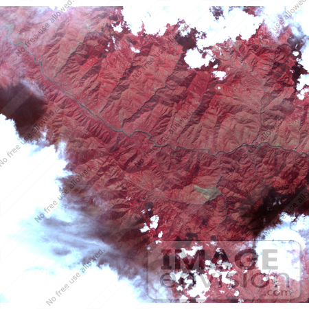
This image acquired by the Advanced Spaceborne Thermal Emission and Reflection Radiometer on NASA's Terra spacecraft on October 11, 2005, depicts a 30-kilometer (19-mile) wide region southeast of the epicenter of the magnitude 7.6 Pakistan earthquake on October 8, 2005, between Muzaffarabad and Uri in the Pir Punjal range of Kashmir. The center of the image is at about 34 degrees, 13 minutes North; 73 degrees, 42 minutes East. A large landslide is visible (brown color) to the south of the main river (Jhelum River) crossing the image. The landslide appears to have blocked the flow of a small river. A number of smaller landslides are also visible, mostly along the main river and other valleys. Photo Credit: NASA/GSFC/METI/ERSDAC/JAROS, and U.S./Japan ASTER Science Team [0003-0612-3123-5256] by 0003
|
Keywords
earth science, geography, jhelum river, jpl, kashmir, landslide, landslide in kashmir, landslides, nasa, pir panjal, pir punjal, science
|
|


