
|
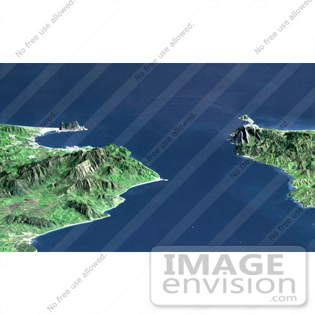
This perspective view shows the Strait of Gibraltar, which is the entrance to the Mediterranean Sea from the Atlantic Ocean. Europe (Spain) is on the left. Africa (Morocco) is on the right. The Rock of Gibraltar, administered by Great Britain, is the peninsula in the back left. The Strait of Gibraltar is the only natural gap in the topographic barriers that separate the Mediterranean Sea from the world's oceans. The Sea is about 3700 kilometers (2300 miles) long and covers about 2.5 million square kilometers (one million square miles), while the Strait is only about 13 kilometers (8 miles) wide. Sediment samples from the bottom of the Mediterranean Sea that include evaporite minerals, soils, and fossil plants show that about five million years ago the Strait was topographically blocked and the Sea had evaporated into a deep basin far lower in elevation than the oceans. Consequent changes in the world's hydrologic cycle, including effects upon ocean salinity, likely led to more ice formation in polar regions and more reflection of sunlight back to space, resulting in a cooler global climate at that time. Today, topography plays a key role in our regional climate patterns. But through Earth history, topographic change, even perhaps over areas as small as 13 kilometers across, has also affected the global climate. Photo Credit: NASA/JPL/NIMA [0003-0612-3123-3712] by 0003
|
Keywords
africa, atlantic ocean, earth science, europe, geography, jpl, mediterranean sea, morocco, nasa, peninsula, sea, spain, strait, strait of gibraltar, the rock of gibraltar
|
|


