
|
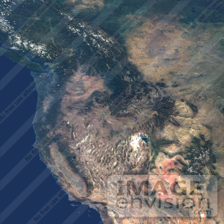
This natural-color image from the Multi-angle Imaging SpectroRadiometer (MISR) captures the beauty of the western United States and Canada. Data from 45 swaths from MISR's vertical-viewing (nadir) camera were combined to create this cloud-free mosaic. The image extends from 48° N 128° W in the northwest, to 32°N, 104° W in the southeast, and has been draped over a shaded relief Digital Terrain Elevation Model from the United States Geological Survey. The image area includes much of British Columbia, Alberta and Saskatchewan in the north, and extends southward to California, Arizona and New Mexico. The snow-capped Rocky Mountains are a prominent feature extending through British Columbia, Montana, Wyoming, Colorado and New Mexico. Many major rivers originate in the Columbia Plateau region of Washington, Oregon and Idaho. The Colorado Plateau region is characterized by the vibrant red-colored rocks of the Painted Desert in Utah and Arizona, and in New Mexico, White Sands National Park is the large white feature in the Southeast corner of the image with the Malpais lava flow just to its North. The southwest is dominated by the Mojave Desert of California and Nevada, California's San Joaquin Valley, the Los Angeles basin and the Pacific Ocean. Photo Credit: NASA/GSFC/LaRC/JPL, MISR Team [0003-0612-3123-0515] by 0003
|
Keywords
alberta, arizona, british columbia, california, canada, colorado, colorado plateau, columbia plateau, earth science, geography, idaho, jpl, los angeles, mojave desert, montana, nasa, nevada, new mexico, oregon, pacific ocean, painted desert, rocky mountains, san joaquin valley, saskatchewan, southwestern canada, united states, usa, utah, washington, western united states, white sands national park, wyoming
|
|


