
|
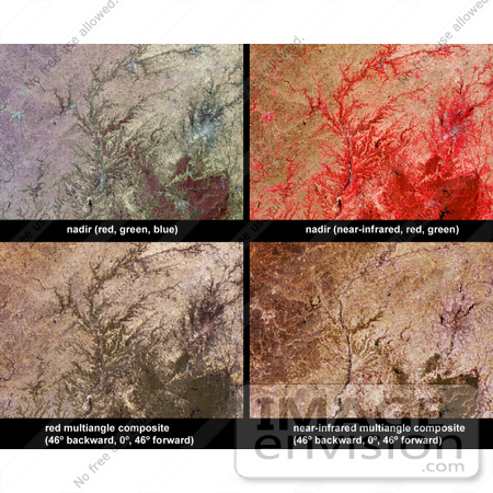
Vegetation across southeast Illinois and central Indiana is shown in this set of multispectral and multiangle images from the Multi-angle Imaging SpectroRadiometer (MISR). Across the center of the image area, the Wabash River runs southward, and in some places corresponds with the Illinois-Indiana border. The White River flows through the city of Indianapolis (to the right of image center), and into Monroe Lake (a dark-colored reservoir at bottom-right). The majority of these fertile lands are used to grow crops, with woodlands present along the rivers and in the rolling hills of South Indiana, indicated in the lower right-hand portion of the images. The top-left panel is a natural color image from MISR's nadir camera, and the top-right panel is false-color image, also from MISR's nadir camera, but displaying data from MISR's near-infrared, red and green bands as red, green and blue, respectively. Living vegetation is highly reflective at near-infrared wavelengths and so appears in red hues in the false-color image. The lower-left panel is a multi-angular composite in which data from the red band of MISR's 46 backward, nadir, and 46 forward viewing cameras are displayed as red, green and blue, respectively. The lower-right panel displays near-infrared band data in the same configuration from the same cameras. Color variations in the angular composites serve as a proxy for changes in angular reflectance, which are in turn influenced by the vegetation structure, terrain, soil type, and the solar illumination conditions. Photo Credit: NASA/GSFC/LaRC/JPL, MISR Team [0003-0612-3120-2155] by 0003
|
Keywords
earth science, environment, environmental, geography, illinois, indiana, indianapolis, jpl, monroe lake, nasa, spring in southeastern illinois and central indiana, vegetation, wabash river, white river
|
|


