
|
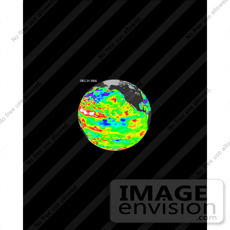
The tropical Pacific Ocean is beginning to exhibit the characteristics of a developing La Nina condition. This image shows that the gradual cooling of the central equatorial Pacific over the past few months is continuing and the area of low sea level (shown in blue) has decreased (cooled) slightly over last few months. It is still uncertain, scientists say, that this cold pool will evolve into a long-lasting, strong La Nina situation. This image of the Pacific Ocean was produced using sea-surface height measurements taken by the U.S.-French Jason satellite. The image shows sea surface height relative to normal ocean conditions on December 31, 2005; these sea surface heights are an indicator of the changing amount of heat stored in the ocean. The purple areas in this image are about 18 centimeters (7 inches) below normal, creating a deficit in the heat supply to the surface waters. The white areas show the sea surface is between 14 and 32 centimeters (6 to 13 inches) above normal; in the red areas, it's about 10 centimeters (4 inches) above normal. The green areas indicate normal conditions. A La Nina situation is essentially the opposite of an El Niño condition. During La Nina, the trade winds are stronger than normal and the cold water that normally exists along the coast of South America extends to the central equatorial Pacific. A La Nina reappears every three to five years and, if the present event strengthens, it will certainly reorganize global weather patterns. Photo Credit: NASA/JPL Ocean Surface Topography Team [0003-0612-3114-4218] by 0003
|
Keywords
earth, earth science, environment, environmental, jpl, la nina, nasa, pacific ocean, science, weather
|
|


