
|
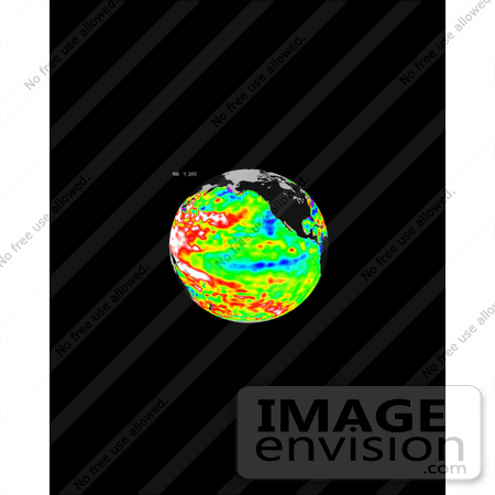
These data, taken during a 10-day collection cycle ending March 9, 2001, show that above-normal sea-surface heights and warmer ocean temperatures (indicated by the red and white areas) still blanket the far-western tropical Pacific and much of the north (and south) mid-Pacific. Red areas are about 10 centimeters (4 inches) above normal; white areas show the sea-surface height is between 14 and 32 centimeters (6 to 13 inches) above normal. This build-up of heat dominating the Western Pacific was first noted by TOPEX/Poseidon oceanographers more than two years ago and has outlasted the El Nino and La Nina events of the past few years. This warmth contrasts with the Bering Sea, Gulf of Alaska and tropical Pacific where lower-than-normal sea levels and cool ocean temperatures continue (indicated by blue areas). The blue areas are between 5 and 13 centimeters (2 and 5 inches) below normal, whereas the purple areas range from 14 to 18 centimeters (6 to 7 inches) below normal. Actually, the near-equatorial ocean cooled through the fall of 2000 and into mid-winter and continues almost La Nina-like. Looking at the entire Pacific basin, the Pacific Decadal Oscillation's warm horseshoe and cool wedge pattern still dominates this sea-level height image. Most recent National Oceanic and Atmospheric Administration (NOAA) sea-surface temperature data also clearly illustrate the persistence of this basin-wide pattern. Photo Credit: NASA/JPL-Caltech [0003-0701-0722-5713] by 0003
|
Keywords
bering sea, earth science, el nino, environment, environmental, gulf of alaska, jpl, la nina, nasa, ocean temperatures, pacific ocean, warm ocean temperatures
|
|


