Picture of Hurricane Henriette Near Mexico #15368


#15368 Picture of Hurricane Henriette Near Mexico by JVPD
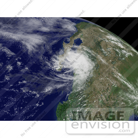
Photo of Hurricane Henriette east-northeast of Loreto, Mexico, moving toward the north at about 12 MPH, with maximum sustained winds near 75 MPH, and higher gusts, August 5th 2007. Centerpoint Latitude: 26:26:54N Longitude: 110:21:18W. [0003-0709-0614-1017] by 0003

Similar Images:

#5066 Stock Photography of Disaster Relief Volunteers Organizing Food for the Victims of Hurricane Hugo by JVPD
#5069 Stock Photography of Homes Destroyed by Hurricane Hugo in Charleston, South Carolina by JVPD
#15357 Picture of Hurricane Dean East-Southeast of Campeche, Mexico by JVPD
#15426 Picture of Tropical Storm Gil Near Guadalajara by JVPD
#15372 Picture of Tropical Cyclone Gonu Southeast of Muscat, Oman by JVPD
#15349 Picture of Hurricane Dean by JVPD
#15352 Picture of Hurricane Dean by JVPD
#33907 Stock Photo of Hurricane Ike Located Southeast Of Galveston, Texas, Moving Toward The West-Northwest At About 13 Mph With Maximum Sustained Winds Near 105 Mph, September 12th 2008 by JVPD
#16066 Picture of Hurricane Humberto Near Louisiana by JVPD
#15429 Picture of Tropical Storm Chantal Near Bermuda by JVPD
#15409 Picture of Tropical Depression Erin by JVPD
#16067 Picture of Hurricane Humberto by JVPD
#15373 Picture of Tropical Cyclone Gonu by JVPD
#15364 Picture of Hurricane Flossie Near Hawaii by JVPD
#15428 Picture of Tropical Storm Dean by JVPD
More Hurricane Photos

Keywords

cyclone, cyclones, earth, earth from space, from space, henriette, henriette hurricane, hurricane, hurricane henriette, hurricanes, mexico, national oceanic and atmospheric administration, nature, noaa, storm, storms, tropical cyclone, tropical cyclones, tropical storm, tropical storms, view from space, weather