|
TERMS OF USE:
This free image can only be used for non-commercial, personal
website use only. THIS IMAGE CANNOT BE
used in galleries, downloaded to your computer, posted on sites for
others to use, manipulated, downsized, or upsized. If you are confused about the
terms of use or have any questions then contact us before using the image.
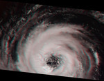
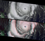
Free Picture: Tropical Storms Bud and Dera
|
Description
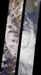
Like dancers pirouetting in opposite directions, the rotational patterns of two different tropical storms are contrasted in this pair of MISR nadir-camera images. The left-hand image is of Tropical Storm Bud, acquired on June 17, 2000 (Terra orbit 2656) as the storm was dissipating. Bud was situated in the eastern Pacific Ocean between Socorro Island and the southern tip of Baja California. South of the storm's center is a vortex pattern caused by obstruction of the prevailing flow by tiny Socorro Island. Sonora, Mexico and Baja California are visible at the top of the image. The right-hand image is of Tropical Cyclone Dera, acquired on March 12, 2001 (Terra orbit 6552). Dera was located in the Indian Ocean, south of Madagascar. The southern end of this large island is visible in the top portion of this image. Northern hemisphere tropical storms, like Bud, rotate in a counterclockwise direction, whereas those in the southern hemisphere, such as Dera, rotate clockwise. The opposite spins are a consequence of Earth's rotation. Each image covers a swath approximately 380 kilometers wide.
Keywords
baja california, bud and dera, earth science, jpl, madagascar, sonora mexico, storm, storms, tropical storm, tropical storm bud, tropical storm dera, tropical storms, tropical storms bud and dera, weather, nasa, free photography, free photo, free photos, free picture, free pictures, free image, free images
|
Similar Free storm Pictures
|
|
|
|