|
TERMS OF USE:
This free image can only be used for non-commercial, personal
website use only. THIS IMAGE CANNOT BE
used in galleries, downloaded to your computer, posted on sites for
others to use, manipulated, downsized, or upsized. If you are confused about the
terms of use or have any questions then contact us before using the image.
Free Picture: Hurricane Debby and the Appalachians

|
Description
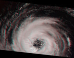
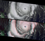
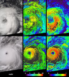
The MISR team has developed new methods for retrieving information about clouds, airborne particles, and surface properties that capitalize on the instrument's unique, multi-angle imaging approach. This illustration, based upon results contained in sample products that have just been publicly released at the Atmospheric Sciences Data Center (ASDC), highlights some of these new capabilities. On August 21, 2000, during Terra orbit 3600, MISR imaged Hurricane Debby in the Atlantic Ocean. The first panel on the left is the MISR downward-looking (nadir) view of the storm's eastern edge. The next two panels show the results of a new approach that uses MISR's stereoscopic observations to retrieve cloud heights and winds. In the middle panel of this set, gradations from low to high cloud are depicted in shades ranging from blue to red. Since it takes seven minutes for all nine MISR cameras to view any location on Earth, and the clouds moved during this time, the data also contain information about wind speed and direction. Derived wind vectors, shown in the third panel, reveal Hurricane Debby's cyclonic motion. The highest wind speed measured is nearly 100 kilometers/hour. MISR obtains this type of information on a global basis, which will help scientists study the relationship between climate change and the three-dimensional characteristics of clouds.
Keywords
appalachians, earth science, hurricane, hurricane debby, hurricanes, jpl, storm, storms, weather, nasa, free photography, free photo, free photos, free picture, free pictures, free image, free images
|
Similar Free storm Pictures
|
|
|
|