|
TERMS OF USE:
This free image can only be used for non-commercial, personal
website use only. THIS IMAGE CANNOT BE
used in galleries, downloaded to your computer, posted on sites for
others to use, manipulated, downsized, or upsized. If you are confused about the
terms of use or have any questions then contact us before using the image.
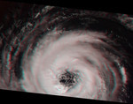
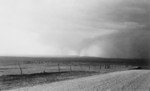
Free Picture: Extratropical Cyclone in the Southern Ocean
|
Description
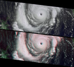
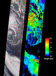
These images from the Multi-angle Imaging SpectroRadiometer portray an occluded extratropical cyclone situated in the Southern Ocean, about 650 kilometers south of the Eyre Peninsula, South Australia. Parts of the Yorke Peninsula and a portion of the Murray-Darling River basin are visible between the clouds near the top of the left-hand image, a true-color view from MISR's nadir(vertical-viewing) camera. Retrieved cloud-tracked wind velocities are indicated by the superimposed arrows. The image on the right displays cloud-top heights. Areas where cloud heights could not be retrieved are shown in black. Both the wind vectors and the cloud heights were derived using data from multiple MISR cameras within automated computer processing algorithms. The stereoscopic algorithms used to generate these results are still being refined, and future versions of these products may show modest changes. Extratropical cyclones are the dominant weather system at midlatitudes, and the term is used generically for region allow-pressure systems in the mid- to high-latitudes. In the southern hemisphere, cyclonic rotation is clockwise. These storms obtain their energy from temperature differences between air masses on either side of warm and cold fronts, and their characteristic pattern is of warm and cold fronts radiating out from a migrating low pressure center which forms, deepens, and dissipates as the fronts fold and collapse on each other. The center of this cyclone has started to decay, with the band of cloud to the south most likely representing the main front that was originally connected with the cyclonic circulation. These views were acquired on October 11, 2001 during Terra orbit 9650, and represent an area of about 380 kilometers x 1900 kilometers.
Keywords
australia, cloud heights, cyclone, cyclones, earth science, extratropical cyclone, extratropical cyclone in the southern ocean, jpl, murray darling river, southern ocean, stereoscopic algorithms, storm, storms, weather, wind vectors, yorke peninsula, nasa, free photography, free photo, free photos, free picture, free pictures, free image, free images
|
Similar Free storm Pictures
|
|
|
|