Manhattan From Space #3632


#3632 Manhattan From Space by JVPD
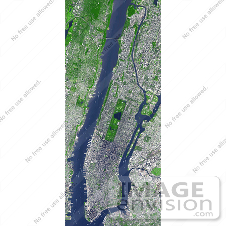
NASA image of New York City and the Island of Manhattan jutting southward from top center, bordered by the Hudson River to the west and the East River to the east. (North is straight up in this scene.) In the middle of Manhattan, Central Park appears as a long green rectangle running roughly north-south with a large lake in the middle. Also visible are parts of Staten Island (bottom left corner) and Long Island (lower right).

Photo Credit: NASA/GSFC/MITI/ERSDAC/JAROS, and U.S./Japan ASTER Science Team [0003-0701-1019-2119] by 0003

Similar Images:

#3573 Great Wall of China From Space by JVPD
#19245 Photo of the Artificial Palm Island, Palm Jumeirah, on the Persian Gulf in Dubai by JVPD
#3253 Lost Hills by JVPD
#25455 Stock Photo of a Vetical Cropped Image of the State of Florida as Seen From Space by JVPD
#2898 Pulau Kimaam, West Papua by JVPD
#26949 Stock Photography of a Map of the Contiguous United States of America and the Great Lakes by JVPD
#35500 Geography Stock Photo Of The Strait Of Magellan, Chile As Seen From Space by JVPD
#2882 Bosporus Strait and Istanbul, Turkey by JVPD
#2685 Picture of World Globes - Three Views of Earth by JVPD
#3343 Cape Cod From Space by JVPD
#3619 Cape Cod From Space by JVPD
#3298 Mexicali, Calexico by JVPD
#3323 Liquefaction Effects, Bhuj Earthquake by JVPD
#3239 Republic of Fiji by JVPD
#3626 Boston From Space by JVPD
More Geography Photos

Keywords

central park, east river, from space, geography, hudson river, island of manhattan, long island, manhattan, manhattan from space, manhattan new york, manhattan ny, nasa, new york city, new york from space, new york ny, ny new york, ny ny, nyc, staten island, view from space