
|
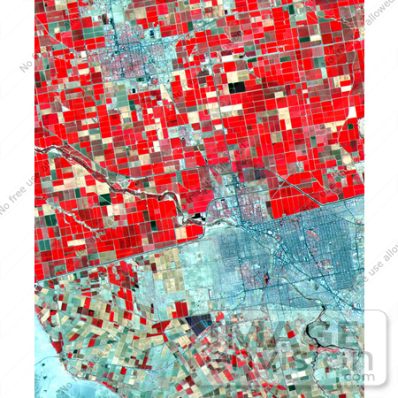
NASA image of Mexicali. Dramatic differences in land use patterns are highlighted in this image of the U.S.-Mexico border. Lush, regularly gridded agricultural fields on the U.S. side contrast with the more barren fields of Mexico This June 12th 2000, sub-scene combines visible and near infrared bands, displaying vegetation in red. The town of Mexicali-Calexico spans the border in the middle of the image; El Centro, California, is in the upper left. Watered by canals fed from the Colorado River, California's Imperial Valley is one of the country's major fruit and vegetable producers. This image covers an area 24 kilometers (15 miles) wide and 30 kilometers (19 miles) long in three bands of the reflected visible and infrared wavelength region. Photo Credit: NASA/GSFC/METI/ERSDAC/JAROS, and U.S./Japan ASTER Science Team [0003-0701-0722-3709] by 0003
|
Keywords
calexico, california, el centro, geography, imperial valley, jpl, mexicali, mexicali calexico, nasa
|
|


