|
TERMS OF USE:
This free image can only be used for non-commercial, personal
website use only. THIS IMAGE CANNOT BE
used in galleries, downloaded to your computer, posted on sites for
others to use, manipulated, downsized, or upsized. If you are confused about the
terms of use or have any questions then contact us before using the image.
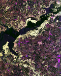
Free Picture: Dnieper River From Space
|
Description
NASA radar image of the intensive agricultural development in central Ukraine, along the Dnieper River. The area shown lies about 320 kilometers (198 miles) southeast of Kiev and about 360 kilometers (223 miles) northeast of Odessa. Central Ukraine is a rich agricultural region, producing primarily wheat and other grains. In this radar image taken in the early spring, most of the fields do not have active crops, so their relatively smooth texture results in dark shades of brown and purple. Boundaries between the fields consist of hedges or trees which appear as bright outlines. The bright yellowish areas along the river are riparian (riverbank) forest. The small tributary that flows into the Dnieper from the right side of the image is the Volch'ya River. Radar images can be used to map crop types, to monitor the health of crops, and to predict yields.
Keywords
agricultural, agriculture, crops, dnieper river, dnieper river from space, from space, geography, jpl, river, rivers, ukraine, view from space, volch ya river, volchya river, nasa, free photography, free photo, free photos, free picture, free pictures, free image, free images
|
Similar Free geography Pictures
|
|
|
|


