|
TERMS OF USE:
This free image can only be used for non-commercial, personal
website use only. THIS IMAGE CANNOT BE
used in galleries, downloaded to your computer, posted on sites for
others to use, manipulated, downsized, or upsized. If you are confused about the
terms of use or have any questions then contact us before using the image.
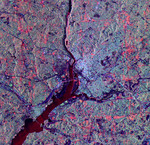
Free Picture: Washington DC From Space

|
Description
NASA image of Washington DC from space. The city of Washington, D.C., is shown is this space radar image. Images like these are useful tools for urban planners and managers, who use them to map and monitor land use patterns. Downtown Washington is the bright area between the Potomac (upper center to lower left) and Anacostia (middle right) rivers. The dark cross shape that is formed by the National Mall, Tidal Basin, the White House and Ellipse is seen in the center of the image. Arlington National Cemetery is the dark blue area on the Virginia (left) side of the Potomac River near the center of the image. The Pentagon is visible in bright white and red, south of the cemetery. Due to the alignment of the radar and the streets, the avenues that form the boundary between Washington and Maryland appear as bright red lines in the top, right and bottom parts of the image, parallel to the image borders.
Keywords
anacostia, anacostia river, arlington national cemetery, dc, ellipse, geography, jpl, maryland, national mall, pentagon, potomac, potomac river, rivers, tidal basin, view from space, washington dc, washington dc from space, white house, nasa, free photography, free photo, free photos, free picture, free pictures, free image, free images
|
Similar Free geography Pictures
|
|
|
|