|
TERMS OF USE:
This free image can only be used for non-commercial, personal
website use only. THIS IMAGE CANNOT BE
used in galleries, downloaded to your computer, posted on sites for
others to use, manipulated, downsized, or upsized. If you are confused about the
terms of use or have any questions then contact us before using the image.
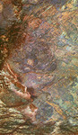
Free Picture: Safsaf Oasis From Space
|
Description
NASA radar image of south-central Egypt demonstrates the unique capability of imaging radar to penetrate thin sand cover in arid regions to reveal hidden details below the surface. Nearly all of the structures seen in this image are invisible to the naked eye and to conventional optical satellite sensors. Features appear in various colors because the three separate radar wavelengths are able to penetrate the sand to different depths. Areas that appear red or orange are places that can be seen only by the longest wavelength, L-band, and they are the deepest of the buried structures. Field studies in this area indicate L-band can penetrate as much as 2 meters (6.5 feet) of very dry sand to image buried rock structures. Ancient drainage channels at the bottom of the image are filled with sand more than 2 meters (6.5 feet) thick and therefore appear dark because the radar waves cannot penetrate them. The fractured orange areas at the top of the image and the blue circular structures in the center of the image are granitic areas that may contain mineral ore deposits. Scientists are using the penetrating capabilities of radar imaging in desert areas in studies of structural geology, mineral exploration, ancient climates, water resources and archaeology.
Keywords
egypt, from space, geography, jpl, oasis, safsaf oasis, safsaf oasis from space, view from space, nasa, free photography, free photo, free photos, free picture, free pictures, free image, free images
|
Similar Free geography Pictures
|
|
|
|


