|
TERMS OF USE:
This free image can only be used for non-commercial, personal
website use only. THIS IMAGE CANNOT BE
used in galleries, downloaded to your computer, posted on sites for
others to use, manipulated, downsized, or upsized. If you are confused about the
terms of use or have any questions then contact us before using the image.
Free Picture: Hong Kong
|
Description
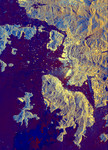
Radar image of Hong Kong from space. The South China Sea is shown in dark blue and red on the image. Land surfaces are seen in shades of lighter blue and gold, including Hong Kong Island in the lower center, the Kowloon Peninsula in the upper right and many other small islands. The brightest yellow areas are the densely developed areas of Hong Kong's business and residential districts. The small yellow dots in the water are the many ships that make Hong Kong one of the busiest seaports in the Far East. Images such as this can be used by land-use planners to monitor urban development and its effect on the tropical environment.
Keywords
far east, from space, geography, hong kong, hong kong from space, hong kong island, jpl, kowloon peninsula, south china sea, view from space, nasa, free photography, free photo, free photos, free picture, free pictures, free image, free images
|
Similar Free geography Pictures
|
|
|
|


