|
TERMS OF USE:
This free image can only be used for non-commercial, personal
website use only. THIS IMAGE CANNOT BE
used in galleries, downloaded to your computer, posted on sites for
others to use, manipulated, downsized, or upsized. If you are confused about the
terms of use or have any questions then contact us before using the image.
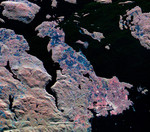
Free Picture: Victoria, Canada From Space
|
Description
NASA radar image of the southern end of Vancouver Island on the west coast of Canada. The white area in the lower right is the city of Victoria, the capital of the province of British Columbia. The three radar frequencies help to distinguish different land use patterns. The bright pink areas are suburban regions, the brownish areas are forested regions, and blue areas are agricultural fields or forest clear-cuts. Founded in 1843 as a fur trading post, Victoria has grown to become one of western Canada's largest commercial centers. In the upper right is San Juan Island, in the state of Washington. The Canada/U.S. border runs through Haro Strait, on the right side of the image, between San Juan Island and Vancouver Island.
Keywords
bc, british columbia, canada, from space, geography, haro strait, jpl, san juan island, vancouver island, victoria, victoria canada from space, victoria from space, view from space, nasa, free photography, free photo, free photos, free picture, free pictures, free image, free images
|
Similar Free geography Pictures
|
|
|
|


