|
TERMS OF USE:
This free image can only be used for non-commercial, personal
website use only. THIS IMAGE CANNOT BE
used in galleries, downloaded to your computer, posted on sites for
others to use, manipulated, downsized, or upsized. If you are confused about the
terms of use or have any questions then contact us before using the image.
Free Picture: Missouri River
|
Description
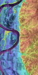
This is a combined radar and topography image of an area along the Missouri River that experienced severe flooding and levee failure in the summer of 1993. The meandering course of the Missouri River is seen as the dark curving band on the left side of the image. The predominantly blue area on the left half of the image is the river's floodplain, which was completely inundated during the flood of 1993. The colors in the image represent elevations, with the low areas shown in purple, intermediate areas in blue, green and yellow, and the highest areas shown in orange. The total elevation range is 85 meters (279 feet). The higher yellow and orange area on the right side of the image shows the topography and drainage patterns typical of this part of the midwestern United States. Dark streaks and bands in the floodplain are agricultural areas that were severely damaged by levee failures during the flooding. The region enclosed by the C-shaped bend in the river in the upper part of the image is Lisbon Bottoms. A powerful outburst of water from a failed levee on the north side of Lisbon Bottoms scoured a deep channel across the fields, which shows up as purple band. As the flood waters receded, deposits of sand and silt were left behind, which now appear as dark, smooth streaks in the image. The yellow areas within the blue, near the river, are clumps of trees sitting on slightly higher ground within the floodplain. The radar "sees" the treetops, and that is why they are so much higher (yellow) than the fields.
Keywords
geography, jpl, missouri river, radar image, radar images, river, rivers, nasa, free photography, free photo, free photos, free picture, free pictures, free image, free images
|
Similar Free geography Pictures
|
|
|
|


