|
TERMS OF USE:
This free image can only be used for non-commercial, personal
website use only. THIS IMAGE CANNOT BE
used in galleries, downloaded to your computer, posted on sites for
others to use, manipulated, downsized, or upsized. If you are confused about the
terms of use or have any questions then contact us before using the image.
Free Picture: Patagonia, Argentina
|
Description
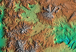
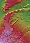
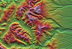
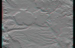
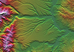
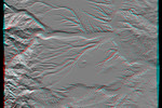
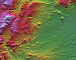
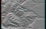
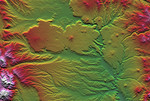
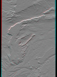
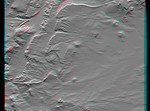
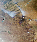
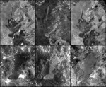
Mosaic consisting of 6 NASA images showing two examples of SRTM radar images (center) with comparisons to images acquired by the Landsat 7 satellite in the visible wavelengths (left) and an infrared wavelength (right). Both sets of images show lava flows in northern Patagonia, Argentina. In each case, the lava flows are relatively young compared to the surrounding rock formations. Generally, the upper flow sits atop much lighter bedrock, providing good contrast and making the edges of the flow distinct. However, the lower flow borders some rocks that are similarly dark, and the flow boundaries are somewhat obscured. Meanwhile, in the radar images (center), image brightness corresponds to surface roughness (and topographic orientation) and substantial differences between the flows are visible. Much of the top flow appears dark, meaning it is fairly smooth. Consequently, it forms little or no contrast with the smooth and dark surrounding bedrock and thus virtually vanishes from view. However, the lower flow appears rough and bright and mostly forms good contrast with adjacent bedrock such that the flow is locally more distinct here than in the visible Landsat view. For further comparison, infrared Landsat images (right) again show image brightnesses related to mineral chemistry, but the lava flows appear lighter than in the visible wavelengths. Consequently, the lower lava flow becomes fairly obscure among the various surrounding rocks, just as the upper flow did in the radar image. The various differences among all of these images illustrate the importance of illumination wavelength in image interpretation. The Landsat 7 Thematic Mapper images used here were provided to the SRTM project by the United States Geological Survey, Earth Resources Observation Systems (EROS) Data Center, Sioux Falls, South Dakota.
Keywords
argentina, geography, jpl, lava flows, patagonia, patagonia argentina, nasa, free photography, free photo, free photos, free picture, free pictures, free image, free images
|
Similar Free argentina Pictures
|
|
|
|