|
TERMS OF USE:
This free image can only be used for non-commercial, personal
website use only. THIS IMAGE CANNOT BE
used in galleries, downloaded to your computer, posted on sites for
others to use, manipulated, downsized, or upsized. If you are confused about the
terms of use or have any questions then contact us before using the image.
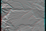
Free Picture: Corral de Piedra, Argentina
|
Description
Volcanism and erosion are prominently seen in this view of the eastern flank of the Andes Mountains taken by Shuttle Radar Topography Mission (SRTM). The area is southeast of San Martin de Los Andes, Argentina. Eroded peaks up to 2,210-meter-high(7,260-foot) are seen on the west (left), but much of the scene consists of lava plateaus that slope gently eastward. These lava flows were most likely derived from volcanic sources in the high mountains. However, younger and more localized volcanic activity is evident in the topographic data as a cone surrounding oval-shaped flow near the center of the scene. The plateaus are extensively eroded by the Rio Limay (bottom of the image) and the Rio Collon Cura and its tributaries (upper half). The larger stream channels have reached a stable level and are now cutting broad valleys. Few terraces between the levels of the high plateaus and lower valleys (bottom center and upper right of the volcanic cone) indicate that stream erosion had once temporarily reached a higher stable level before eroding down to its current level. In general, depositional surfaces like lava flows are progressively younger with increasing elevation, while erosional surfaces are progressively younger with decreasing elevation. This anaglyph was produced by first shading a preliminary SRTM elevation model. The stereoscopic effect was then created by generating two differing perspectives, one for each eye. When viewed through special glasses, the result is a vertically exaggerated view of the Earth's surface in its full three dimensions. Anaglyph glasses cover the left eye with a red filter and cover the right eye with a blue filter.
Keywords
3d, anaglyph, anaglyphs, argentina, corral de piedra, corral de piedra argentina, geography, jpl, lava plateaus, rio collon cura, rio limay, san martin de los andes, nasa, free photography, free photo, free photos, free picture, free pictures, free image, free images
|
Similar Free geography Pictures
|
|
|
|


