|
TERMS OF USE:
This free image can only be used for non-commercial, personal
website use only. THIS IMAGE CANNOT BE
used in galleries, downloaded to your computer, posted on sites for
others to use, manipulated, downsized, or upsized. If you are confused about the
terms of use or have any questions then contact us before using the image.
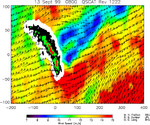
Free Picture: South Georgia Island
|
Description
Image of winds near South Georgia Island. Winds are blocked by an island mountain barrier that produces a long "shadow" of low winds on the downwind side of the island stretching for hundreds of kilometers (about 500 miles long) in this image produced from data from NASA's SeaWinds instrument on the Quikscat satellite. South Georgia Island, in the South Atlantic Ocean (approximately 1,500 kilometers, or miles, east of the Falkland/Malvinas Islands, is only 170 kilometers long (about 106 miles) and 30 kilometers (about 19 miles)wide, but contains 13 peaks exceeding 2,000 meters (more than 6,500 feet) in height. The island thus acts as a significant barrier to the surface winds in this forbidding part of the world oceans. Mountainous islands and steep coastal topography can modify the surface wind field for many hundreds of kilometers seaward. The detailed air-sea-land interaction processes involved are not well understood, largely because of a lack of accurate, high-resolution, extensive wind speed and direction measurements. The broad-swath, all-weather SeaWinds instrument on NASA's Quikscat satellite is providing unique measurements of ocean winds, revealing previously unknown wind patterns caused by island topography and allowing development of improved models for coastal ocean winds. This image shows QuikScat measurements of wind speed and direction during a single pass over South Georgia Island on September 13, 1999. The island itself is shown as black (for heights less than 750 meters(less than half a mile), green (for heights between 750 and 1,500 meters (less than half a mile to about one mile), and red (for regions greater than 1,500 meters, or about one mile in altitude). The white area surrounding the island represents the region where land contamination does not allow wind measurements to be made. The horizontal and vertical coordinates are in kilometers, with origin on the island at latitude 54.5 degrees south, longitude 30 degrees east. This large-scale
Keywords
earth science, geography, island, islands, jpl, sea winds, seawinds, south georgia island, winds, nasa, free photography, free photo, free photos, free picture, free pictures, free image, free images
|
Similar Free geography Pictures
|
|
|
|


