|
TERMS OF USE:
This free image can only be used for non-commercial, personal
website use only. THIS IMAGE CANNOT BE
used in galleries, downloaded to your computer, posted on sites for
others to use, manipulated, downsized, or upsized. If you are confused about the
terms of use or have any questions then contact us before using the image.
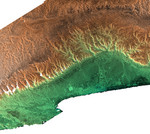
Free Picture: Salalah, Oman
|
Description
Radar image including the city of Salalah, the second largest city in Oman. It illustrates how topography determines local climate and, in turn, where people live. This area on the southern coast of the Arabian Peninsula is characterized by a narrow coastal plain (bottom) facing southward into the Arabian Sea, backed by the steep escarpment of the Qara Mountains. The backslope of the Qara Mountains slopes gently into the vast desert of the Empty Quarter (at top). This area is subject to strong monsoonal storms from the Arabian Sea during the summer, when the mountains are enveloped in a sort of perpetual fog. The moisture from the monsoon enables agriculture on the Salalah plain, and also provides moisture for Frankincense trees growing on the desert (north) side of the mountains. In ancient times, incense derived from the sap of the Frankincense tree was the basis for an extremely lucrative trade. Radar and topographic data are used by historians and archaeologists to discover ancient trade routes and other significant ruins.
Keywords
arabian sea, geography, jpl, oman, qara mountains, salalah, salalah oman, nasa, free photography, free photo, free photos, free picture, free pictures, free image, free images
|
Similar Free geography Pictures
|
|
|
|


