|
TERMS OF USE:
This free image can only be used for non-commercial, personal
website use only. THIS IMAGE CANNOT BE
used in galleries, downloaded to your computer, posted on sites for
others to use, manipulated, downsized, or upsized. If you are confused about the
terms of use or have any questions then contact us before using the image.
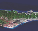
Free Picture: Oahu, Hawaii
|
Description
Image of Honolulu, on the island of Oahu. This perspective view, combining a Landsat image with SRTM topography, shows how the topography controls the urban growth pattern, causes cloud formation, and directs the rainfall runoff pattern. Features of interest in this scene include downtown Honolulu (right), Honolulu Harbor (right), Pearl Harbor (center), and offshore reef patterns (foreground). The Koolau mountain range runs through the center of the image. On the north shore of the island are the Mokapu Peninsula and Kaneohe Bay (upper right). Clouds commonly hang above ridges and peaks of the Hawaiian Islands, and in this rendition appear draped directly on the mountains. The clouds are actually about 1000 meters (3300 feet) above sea level.
Keywords
geography, hawaii, hawaiian islands, honolulu, honolulu harbor, island, islands, jpl, kaneohe bay, koolau, koolau mountain range, mokapu peninsula, oahu, oahu hawaii, pearl harbor, nasa, free photography, free photo, free photos, free picture, free pictures, free image, free images
|
Similar Free geography Pictures
|
|
|
|


