|
TERMS OF USE:
This free image can only be used for non-commercial, personal
website use only. THIS IMAGE CANNOT BE
used in galleries, downloaded to your computer, posted on sites for
others to use, manipulated, downsized, or upsized. If you are confused about the
terms of use or have any questions then contact us before using the image.
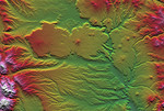
Free Picture: Patagonia, Argentina
|
Description
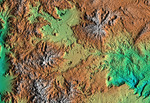
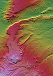
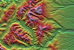
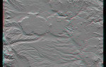
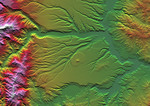
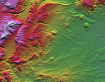
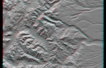
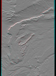
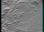
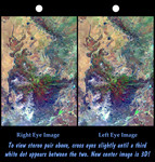
This view of northern Patagonia, at Los Menucos, Argentina shows remnants of relatively young volcanoes built upon an eroded plain of much older and contorted volcanic, granitic, and sedimentary rocks. The large purple, brown, and green "butterfly" pattern is a single volcano that has been deeply eroded. Large holes on the volcano's flanks indicate that they may have collapsed soon after eruption, as fluid molten rock drained out from under its cooled and solidified outer shell. At the upper left, a more recent eruption occurred and produced a small volcanic cone and a long stream of lava, which flowed down a gully. At the top of the image, volcanic intrusions permeated the older rocks resulting in a chain of small dark volcanic peaks. At the top center of the image, two halves of a tan ellipse pattern are offset from each other. This feature is an old igneous intrusion that has been split by a right-lateral fault. The apparent offset is about 6.6 kilometers (4 miles). Color, tonal, and topographic discontinuities reveal the fault trace as it extends across the image to the lower left. However, young unbroken basalt flows show that the fault has not been active recently. This cross-eyed stereoscopic image pair was generated using topographic data from the Shuttle Radar Topography Mission, combined with an enhanced Landsat 7satellite color image. The topography data are used to create two differing perspectives of a single image, one perspective for each eye. In doing so, each point in the image is shifted slightly, depending on its elevation. When stereoscopically merged, the result is a vertically exaggerated view of the Earth's surface in its full three dimensions.
Keywords
argentina, geography, jpl, los menucos, patagonia, patagonia argentina, nasa, free photography, free photo, free photos, free picture, free pictures, free image, free images
|
Similar Free argentina Pictures
|
|
|
|