|
TERMS OF USE:
This free image can only be used for non-commercial, personal
website use only. THIS IMAGE CANNOT BE
used in galleries, downloaded to your computer, posted on sites for
others to use, manipulated, downsized, or upsized. If you are confused about the
terms of use or have any questions then contact us before using the image.
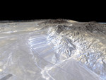
Free Picture: Garlock Fault
|
Description
Image of California's Garlock Fault, marking the northwestern boundary of the Mojave Desert, lies at the foot of the mountains, running from the lower right to the top center of this image, which was created with data from NASA's shuttle Radar Topography Mission (SRTM), flown in February 2000. These mountains are the southern end of the Sierra Nevada and the prominent canyon emerging at the lower right is Lone Tree canyon. In the distance, the San Gabriel Mountains cut across from the leftside of the image. At their base lies the San Andreas Fault which meets the Garlock Fault near the left edge at Tejon Pass. The dark linear feature running from lower right to upper left is State Highway 14 leading from the town of Mojave in the distance to Inyokern and the Owens Valley in the north. The lighter parallel lines are dirt roads related to power lines and the Los Angeles Aqueduct which run along the base of the mountains.
Keywords
earth science, fault, faults, garlock fault, jpl, lone tree canyon, los angeles aqueduct, san andreas fault, san gabriel mountains, san gabriel mtns, state highway 14, tejon pass, nasa, free photography, free photo, free photos, free picture, free pictures, free image, free images
|
Similar Free geography Pictures
|
|
|
|


