|
TERMS OF USE:
This free image can only be used for non-commercial, personal
website use only. THIS IMAGE CANNOT BE
used in galleries, downloaded to your computer, posted on sites for
others to use, manipulated, downsized, or upsized. If you are confused about the
terms of use or have any questions then contact us before using the image.
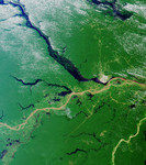
Free Picture: Rio Solimoes and the Rio Negro
|
Description
Close to the city of Manaus, Brazil the Rio Solimoes and the Rio Negro converge to form the Amazon River. This image from MISR's vertical-viewing (nadir) camera was acquired on July 23, 2000 during Terra orbit 3178. Manaus is the gray patch to the right of image center. The pale, murky color of the Rio Solimoes heralds its burden of glacial silt and sand, which results from its origin in the Peruvian Andes mountains. The dark color of the Rio Negro is characteristic of clear waters that originate in areas of basement rock and carry little sediment. East of Manaus the pale and dark waters flow side-by-side as distinct flows before they eventually merge. Northwest of Manaus on the Rio Negro is the Anavilhanas Archipelago, the largest group of freshwater islands in the world and a wildlife reserve. At the top of the image, a portion of the dark-colored Uatuma River is visible. In the lower right is the very light-colored Rio Madeira, formed from mountain streams originating near the Brazil-Bolivia border. Madeira is Portuguese for wood, and the river is named for the large amount of driftwood that floats on its waters.
Keywords
amazon river, anavilhanas archipelago, brazil, geography, jpl, manaus, rio madeira, rio negro, rio solimoes, river, rivers, uatuma river, nasa, free photography, free photo, free photos, free picture, free pictures, free image, free images
|
Similar Free geography Pictures
|
|
|
|


