|
TERMS OF USE:
This free image can only be used for non-commercial, personal
website use only. THIS IMAGE CANNOT BE
used in galleries, downloaded to your computer, posted on sites for
others to use, manipulated, downsized, or upsized. If you are confused about the
terms of use or have any questions then contact us before using the image.
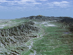
Free Picture: Caliente Range and Cuyama Valley
|
Description
Before the arrival of Europeans, California's Cuyama Valley was inhabited by Native Americans who were culturally and politically tied to the Chumash tribes of coastal Santa Barbara County. Centuries later, the area remains the site of noted Native American rock art paintings. In the 1800s, when Europeans established large cattle and horse-breeding ranches in the valley, the early settlers reported the presence of small villages along the Cuyama River. This perspective view looks upstream toward the southeast through the Cuyama Valley. The Caliente Range, with maximum elevations of 1,550 meters (5,085 feet), borders the valley on the left. The Cuyama River, seen as a bright meandering line on the valley floor, enters the valley from headwaters more than 2,438 meters (8,000 feet) above sea level near Mount Abel and flows 154 kilometers (96 miles) before emptying into the Pacific Ocean. The river's course has been determined in large part by displacement along numerous faults. Today, the Cuyama Valley is the home of large ranches and small farms. The area has a population of 1,120 and is more than an hour and a half drive from the nearest city in the county.
Keywords
caliente range, caliente range and cuyama valley, california, cuyama river, cuyama valley, geography, jpl, mount abel, mt abel, valley, nasa, free photography, free photo, free photos, free picture, free pictures, free image, free images
|
Similar Free geography Pictures
|
|
|
|


