|
TERMS OF USE:
This free image can only be used for non-commercial, personal
website use only. THIS IMAGE CANNOT BE
used in galleries, downloaded to your computer, posted on sites for
others to use, manipulated, downsized, or upsized. If you are confused about the
terms of use or have any questions then contact us before using the image.
Free Picture: Liquefaction Effects, Bhuj Earthquake
|
Description
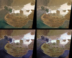
These MISR images show the Kachchh region in the Gujarat province of western India. On January 26 2001, a magnitude 7.7 earthquake devastated this area, killing 20,000 people and destroying buildings, dams, and port facilities. The two upper MISR images are pre- and post-earthquake scenes acquired on January 15 and January 31, 2001, respectively (Terra orbits 5736 and 5969). They are "true-color" images made by combining the red, green and blue bands from the nadir (vertically down-looking) camera. The two lower views are "false-color" images made by combining the red bands from three different cameras. Blue is assigned to the camera pointing 70 degrees forward (more sun-facing), green to the nadir camera, and red to the camera pointing 70 degrees aftward. Each of these images is about 275 kilometers wide by 218 kilometers high. The earthquake epicenter was just below the southern tip of the large, white area on the right-hand side of the images, and about 70 kilometers northeast of the city of Bhuj. The earthquake may have occurred on the Kachchh Mainland Fault, which extends from the region of the epicenter westward along the curved boundary between the darker brown region to the south and the lighter brown area north of it. The compressive stresses responsible for the earthquake are related to the collision of India with Asia and the resulting rise of the Himalayas to the northeast. That part of the Kachchh region which lies north of the Kachchh Mainland Fault includes the Banni Plains and the Rann of Kachchh. It is a low, flat basin characterized by salt pans and mud flats. The salt forms in the Rann of Kachchh as mineral-laden waters evaporate. The salt flats can be seen in the nadir images as highly reflective, white and gray areas. During the earthquake, strong shaking produced liquefaction in the fine silts and sands below the water table in the Rann of Kachchh. This caused the mineral grains to settle and expel their interstitial water to the surface. Field
Keywords
banni plains, bhuj, bhuj earthquake, delta, earth science, earthquake, earthquakes, fault, faults, geography, gujarat, gujarat province, himalayas, india, indus river valley, jpl, kachchh, kachchh mainland fault, kachchh region, liquefaction effects, mud flats, nagar parkar fault, pakistan, rann of kachchh, salt flats, salt pans, sand dunes, thar desert, nasa, free photography, free photo, free photos, free picture, free pictures, free image, free images
|
Similar Free geography Pictures
|
|
|
|


