|
TERMS OF USE:
This free image can only be used for non-commercial, personal
website use only. THIS IMAGE CANNOT BE
used in galleries, downloaded to your computer, posted on sites for
others to use, manipulated, downsized, or upsized. If you are confused about the
terms of use or have any questions then contact us before using the image.
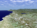
Free Picture: Ventura, and Lake Casitas
|
Description
Ventura, California is one of this state's oldest cities. Officially known as San Buenaventura, it was established in 1782 with the founding of the Mission San Buenaventura, the ninth of the 21 Spanish missions founded in California. In this perspective view generated from SRTM elevation data, the city can be seen occupying the shore of the Pacific Ocean and the nearby foothills. Lake Casitas, a reservoir and popular recreation area, is the dark blue feature in the center of the image. Holding back the 313,000 megaliter (254,000 acre-feet) storage capacity of the reservoir and visible as a very bright feature foreground of the lake, is the Casitas Dam, a 102-meter(334-foot) Earth fill dam. The reservoir and dam were built between 1956 and 1959 for the Federal Bureau of Reclamation's Ventura River Project. In addition to recreational use, Lake Casitas provides irrigation, municipal and industrial water to urban and suburban areas in Ventura County. For visualization purposes, topographic heights displayed in this image are exaggerated two times.
Keywords
ca, calif, california, casitas dam, foothills, geography, jpl, lake, lake casitas, lakes, reservoir, san buenaventura, ventura, ventura california, nasa, free photography, free photo, free photos, free picture, free pictures, free image, free images
|
Similar Free geography Pictures
|
|
|
|


