|
TERMS OF USE:
This free image can only be used for non-commercial, personal
website use only. THIS IMAGE CANNOT BE
used in galleries, downloaded to your computer, posted on sites for
others to use, manipulated, downsized, or upsized. If you are confused about the
terms of use or have any questions then contact us before using the image.
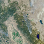
Free Picture: Emigrant Gap Fire
|
Description
These Multi-angle Imaging SpectroRadiometer images of the Central Valley and the Sierra Nevada Mountains show several smoke plumes from wildfires burning throughout Northern California on August 13, 2001. The overview image represents an area of 336 kilometers by 332 kilometers, and was acquired by MISR's 46-degree backward-looking camera during Terra orbit 8802. The most prominent plume arises from the Emigrant Gap Fire, located about 40 kilometers west of Lake Tahoe. The Emigrant Gap Fire started during the early afternoon of August 12 and was the result of human activity. It was contained within four days, and burned about 2,500 acres in total. Also visible in the overview image are smoke plumes from the Blue Complex Fires (upper right) and the Trough Fire (lower left). The round hill in the Central Valley is Sutter Buttes, and the single snowcapped peak in the upper left is Mount Shasta. As of August 30, the US Forest Service reported the total year-to-date area burned in Northern California to be in excess of 200,000 acres, or 800 square kilometers.
Keywords
blue complex fires, california, central valley, emigrant gap fire, environment, environmental, fire, fires, geography, jpl, lake tahoe, mount shasta, mt shasta, sierra nevada mountains, smoke plume, smoke plumes, sutter buttes, trough fire, wild fire, wild fires, wildfire, wildfires, nasa, free photography, free photo, free photos, free picture, free pictures, free image, free images
|
Similar Free geography Pictures
|
|
|
|


