|
TERMS OF USE:
This free image can only be used for non-commercial, personal
website use only. THIS IMAGE CANNOT BE
used in galleries, downloaded to your computer, posted on sites for
others to use, manipulated, downsized, or upsized. If you are confused about the
terms of use or have any questions then contact us before using the image.
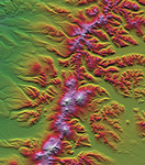
Free Picture: Sredinnyy Khrebet, Kamchatka Peninsula
|
Description
The Kamchatka Peninsula in eastern Russia is shown in this scene created from a preliminary elevation model derived from the first data collected during the Shuttle Radar Topography Mission (SRTM) on February 12, 2000. Sredinnyy Khrebet, the mountain range that makes up the spine of the peninsula, is a chain of active volcanic peaks. Pleistocene and recent glaciers have carved the broad valleys and jagged ridges that are common here. The relative youth of the volcanism is revealed by the topography as infilling and smoothing of the otherwise rugged terrain by lava, ash, and pyroclastic flows, particularly surrounding the high peaks in the south central part of the image. Elevations here range from near sea level up to 2,618 meters (8,590 feet). Two visualization methods were combined to produce this image: shading and color coding of topographic height. The shade image was derived by computing topographic slope in the north-south direction. Northern slopes appear bright and southern slopes appear dark. Color coding is directly related to topographic height, with green at the lower elevations, rising through yellow, red, and magenta, to white at the highest elevations.
Keywords
geography, jpl, kamchatka peninsula, mountain range, mountain ranges, russia, sredinnyy khrebet, nasa, free photography, free photo, free photos, free picture, free pictures, free image, free images
|
Similar Free geography Pictures
|
|
|
|


