|
TERMS OF USE:
This free image can only be used for non-commercial, personal
website use only. THIS IMAGE CANNOT BE
used in galleries, downloaded to your computer, posted on sites for
others to use, manipulated, downsized, or upsized. If you are confused about the
terms of use or have any questions then contact us before using the image.
Free Picture: St. Louis, Missouri
|
Description
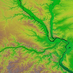
The confluence of the Mississippi, Missouri and Illinois rivers are shown in this view of the St. Louis area from the Shuttle Radar Topography Mission. The Mississippi flows from the upper left of the image and first meets the Illinois, flowing southward from the top right. It then joins the Missouri, flowing from the west across the center of the picture. The rivers themselves appear black here, and one can clearly see the green-colored floodplains in which they are contained. These floodplains are at particular risk during times of flooding. The Mississippi forms the state boundary between Illinois (to the right) and Missouri (to the left), with the city of St. Louis located on the Mississippi just below the point where it meets the Missouri. This location at the hub of the major American waterways helped establish St. Louis' reputation as the "Gateway to the West. Two visualization methods were combined to produce this image: shading and color coding of topographic height. The shade image was derived by computing topographic slope in the northwest-southeast direction. North-facing slopes appear bright and south-facing slopes appear dark. Color coding is directly related to topographic height, with blue and green at the lower elevations, rising through yellow and brown to white at the highest elevations.
Keywords
floodplains, geography, illinois river, jpl, mississippi river, missouri, missouri river, nasa, river, rivers, st louis missouri, st louis, free photography, free photo, free photos, free picture, free pictures, free image, free images
|
Similar Free geography Pictures
|
|
|
|


