|
TERMS OF USE:
This free image can only be used for non-commercial, personal
website use only. THIS IMAGE CANNOT BE
used in galleries, downloaded to your computer, posted on sites for
others to use, manipulated, downsized, or upsized. If you are confused about the
terms of use or have any questions then contact us before using the image.
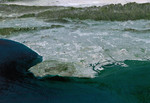
Free Picture: Los Angeles Basin
|
Description
Most of Los Angeles is visible in this computer-generated north-northeast perspective viewed from above the Pacific Ocean. In the foreground the hilly Palos Verdes peninsula lies to the left of the harbor at Long Beach, and in the middle distance the various communities that comprise the greater Los Angeles area appear as shades of grey and white. In the distance the San Gabriel Mountains rise up to separate the basin from the Mojave Desert, which can be seen near the top of the image. This 3-D perspective view was generated using topographic data from the Shuttle Radar Topography Mission (SRTM) and an enhanced color Landsat 5satellite image mosaic. Topographic expression is exaggerated one and one-half times.
Keywords
3d, ca, calif, california, geography, jpl, la, long beach, los angeles, los angeles ca, los angeles calif, los angeles california, mojave desert, nasa, palos verdes, palos verdes peninsula, san gabriel mountains, los angeles basin, free photography, free photo, free photos, free picture, free pictures, free image, free images
|
Similar Free geography Pictures
|
|
|
|


