|
TERMS OF USE:
This free image can only be used for non-commercial, personal
website use only. THIS IMAGE CANNOT BE
used in galleries, downloaded to your computer, posted on sites for
others to use, manipulated, downsized, or upsized. If you are confused about the
terms of use or have any questions then contact us before using the image.
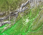
Free Picture: Madrid, Spain

|
Description
The white, mottled area in the right-center of this image from NASA's Shuttle Radar Topography Mission (SRTM) is Madrid, the capital of Spain. Located on the Meseta Central, a vast plateau covering about 40 percent of the country, this city of 3 million is very near the exact geographic center of the Iberian Peninsula. The Meseta is rimmed by mountains and slopes gently to the west and to the series of rivers that form the boundary with Portugal. The plateau is mostly covered with dry grasslands, olive groves and forested hills. Madrid is situated in the middle of the Meseta, and at an elevation of 646 meters (2,119 feet) above sea level is the highest capital city in Europe. To the northwest of Madrid, and visible in the upper left of the image, is the Sistema Central mountain chain that forms the "dorsal spine" of the Meseta and divides it into northern and southern subregions. Rising to about 2,500 meters (8,200 feet), these mountains display some glacial features and are snow-capped for most of the year. Offering almost year-round winter sports, the mountains are also important to the climate of Madrid.
Keywords
dorsal spine, geography, iberian peninsula, madrid spain, meseta, meseta central, plateau, sistema central mountain, sistema central mountain chain, spain, madrid, free photography, free photo, free photos, free picture, free pictures, free image, free images
|
Similar Free geography Pictures
|
|
|
|