|
TERMS OF USE:
This free image can only be used for non-commercial, personal
website use only. THIS IMAGE CANNOT BE
used in galleries, downloaded to your computer, posted on sites for
others to use, manipulated, downsized, or upsized. If you are confused about the
terms of use or have any questions then contact us before using the image.
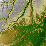
Free Picture: Iturralde Structure, Bolivia
|
Description
An 8-kilometer (5-mile) wide crater of possible impact origin is shown in this view of an isolated part of the Bolivian Amazon from the Shuttle Radar Topography Mission. The circular feature at the center-left of the image, known as the Iturralde Structure, is possibly the Earth's most recent "big" impact event recording collision with a meteor or comet that might have occurred between 11,000 and 30,000 years ago. Although the structure was identified on satellite photographs in the mid-1980s, its location is so remote that it has only been visited by scientific investigators twice, most recently by a team from NASA's Goddard Space Flight Center in September 2002. Lying in an area of very low relief, the landform is a quasi-circular closed depression only about 20 meters (66 feet) in depth, with sharply defined sub-angular "rim" materials. It resembles a "cookie cutter" in that its appearance "cuts" the heavily vegetated soft-sediments and pampas of this part of Bolivia. The SRTM data have provided investigators with the first topographic map of the site and will allow studies of its three-dimensional structure crucial to determining whether it actually is of impact origin. Two visualization methods were combined to produce this image: shading and color coding of topographic height. The shade image was derived by computing topographic slope in the northwest-southeast direction. North-facing slopes appear bright and south-facing slopes appear dark. Color coding is directly related to topographic height, with brown and green at the lower elevations, rising through yellow and brown to white at the highest elevations.
Keywords
bolivia, bolivian amazon, geography, iturralde structure bolivia, jpl, nasa, iturralde structure, free photography, free photo, free photos, free picture, free pictures, free image, free images
|
Similar Free geography Pictures
|
|
|
|


